Template file
This is a DRAINS .drn file that contains data base information on hydrological models, rainfall data, and the pipe, pit and overflow route types that can be used in a particular region, or for specific applications. An example might be a file containing hydrological models acceptable to a council, the local rainfall patterns, and customary pipe, pit and road cross-sections applied for subdivision design in a local government area.
It can be established by closing a DRAINS model with the desired characteristics, and then saving the blank model that remains, ensuring that the pipe, pit and overflow route data bases have not changed, and if necessary, importing a required Default data base.
A more controlled way is to use the Export → Drains Template File option from the File menu, which opens the following dialog box:
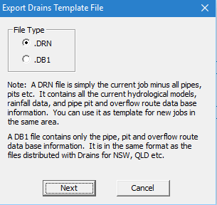
You can nominate the file type and click on Next to locate the folder in which the file is to be stored and to nominate a filename, such as Fairford Template.drn, or Dalesworth Pits.db1.
The .drn files can be simply opened and renamed before entering a new system.
It can be established by closing a DRAINS model with the desired characteristics, and then saving the blank model that remains, ensuring that the pipe, pit and overflow route data bases have not changed, and if necessary, importing a required Default data base.
A more controlled way is to use the Export → Drains Template File option from the File menu, which opens the following dialog box:
You can nominate the file type and click on Next to locate the folder in which the file is to be stored and to nominate a filename, such as Fairford Template.drn, or Dalesworth Pits.db1.
The .drn files can be simply opened and renamed before entering a new system.
Related Articles
File menu
You can use the File menu to open or close files and to save them. Some options should be familiar to you, since they are used in familiar Windows applications, such as word-processors and spreadsheets. The options available are: Selecting Open takes ...General Instructions
(a) Setting up DRAINS models On most PC systems the installation process will put a DRAINS icon on the Programs folder in your Start menu, and you can start DRAINS by clicking on this. If this icon is not present, you can create Shortcut icon on your ...Merging files
DRAINS allows models of systems that have the same base to be joined together using the merging procedure: (a) Edit the files for the two models so that there are two adjacent pits with the same names in both files (these can be dummy pits entered by ...Importing MapInfo files
This process enables you to import data into DRAINS from one to six sets of MapInfo files, plus an optional background from a DXF file. The procedure is pretty much the reverse of the exporting process for MapInfo files. MapInfo stores spatial ...Importing ESRI files
This process enables you to import data into DRAINS from one to six sets of ESRI or ArcView files, plus an optional background from a DXF file. The procedure is pretty much the reverse of the exporting process for ESRI files. ArcView stores spatial ...