(a) General
As well as the standard Horton (ILSAX) hydrological model for simulating flows from urban areas, DRAINS has optional storage routing models based on procedures applied in three hydrological models that have been used in Australia since the 1970s - RORB, RAFTS and WBNM.
These allow users to model large catchments in a similar manner to the "runoff routing" programs, RORB, RAFTS and WBNM, using catchments and the stream reaches that connect them as non-linear storage flow routing elements.
These can be used to determine flows at many points within a catchment. In a typical rural study, the model would be set up on the basis of catchment topography and the pattern of the stream network. If gauging data were available, the model would then be calibrated by adjusting the routing parameters for the selected model type until there was good agreement between the hydrographs produced by the model and gauged catchment hydrographs. Following this, the model could then be applied with larger design floods to assess the flows at critical locations.
The facilities in DRAINS expand on those available in earlier programs, because it is possible to run some sub-catchments with Horton (ILSAX) hydrology and others with storage routing hydrology at the same time. Situations such as an urban drainage system influenced by tailwater from a large stream can be consistently modelled. DRAINS also offers the choice of modelling stream hydraulic grade lines exactly by specifying open channels, or by routing flows through a routed stream reach.
These belong to a class of models termed runoff routing models, which also includes models based on unit hydrograph and kinematic wave calculations. Runoff routing models can "route" a hydrograph from one geographical location to another, allowing for changes such as attenuation of the hydrograph.
The basic non-linear model used in Australian storage routing models was developed by Eric Laurenson. RORB, a practical computer application of this model, was developed by Eric Laurenson, Russell Mein and Tom McMahon at Monash University, Melbourne, and released in the mid 1970s. At the same time the RSWM (Regional Stormwater Model) was developed by Allan Goyen of Willing & Partners and Tony Aitken of SMEC. These models were immediately popular, as they filled a need for modelling mixed rural and urban catchments, allowing for soil and rainfall variability, and providing flow estimates at points throughout the catchment. They were followed by the WBNM (Watershed Bounded Network Model) of Michael Boyd of the University of Wollongong, and David Pilgrim and Ian Cordery of the University of New South Wales in 1979.
Initially, these models were run on mainframe and mini computers. RAFTS (Runoff Analysis and Flow Training Simulation), an enhanced version of RSWM, was released in 1983 and sold commercially by Willing & Partners (later WP Software and XP-Software). This includes continuous modeling processes as well as the storage routing model discussed here. A version for IBM-compatible PCs was released in 1987. A PC version of RORB was released in 1988.
WBNM was revised in 1987 and a new version was produced by Michael Boyd, Ted Rigby of Forbes Rigby Associates and Rudy VanDrie of Balance Research and Development in 1994. This modeled urban catchments. WBNM2000, introduced in 1999, used a different structure to earlier models and added many features.
A number of other storage routing models using non-linear routing have been developed, but have not had the wide use or long development history of the RORB, RAFTS and WBNM models. The most prominent of these is URBS, developed by Don Carroll, which is to used for flood forecasting and specialised studies, but not for general design.
Runoff routing methods have been covered in Australian Rainfall and Runoff (Chapter 9, 1987 and or Book 5, Section 3, 1998), where regional estimates of parameters are provided.
Each of the models has been developed on different principles. RORB performs calculations based on the equation:
S = k . Qm, where S is storage (m3), k and m are parameters, with m usually being 0.8, and Q is flowrate (m3/s).
The routing factor k is defined as kc . kr, where kc is a general routing factor applicable to all sub-catchments, and kr is a factor for a particular sub-catchment, being the ratio of the stream length running through that sub-catchment and the average flow distance from sub-catchments to the catchment outlet. kc acts as a calibration parameter, enabling the model's results to be varied and fitted to recorded hydrographs. A kc of 0.0 will perform no routing, so that values of rainfall excess and flows from upstream storages will pass through a sub-catchment unchanged. A kc that is very large will delay flows considerable, so that flowrates will be very low. By adjusting kc, the peak of a calculated hydrograph can be varied over the range from the peak rate of rainfall excess to zero. Decreasing kc increases flowrates.
For sub-catchment routing, RAFTS uses the equation:
S = BX . IBFL . PERN . 0.285 A0.52. (1+U)-1.97. Sc-0.50. Q1+n
Where BX is a calibration factor similar to RORB's kc, IBFL is a factor for modeling overbank flow, PERN is a factor that adjusts the catchment routing factor to allow for catchment roughness, A is the sub-catchment area (km2), U is the fraction of the catchment that is urbanized, Sc is the main drainage slope of the sub-catchment, and n is the sub-catchment storage exponent. The exponent n defines the non-linearity of the sub-catchment response, and the default value is -0.285.
For routing along stream reaches, RAFTS applies a translation over a nominated time, or performs Muskingum-Cunge routing based on the stream cross-section and roughness.
For sub-catchments, WBNM uses the routing equation:
S = 60 . LP. A0.57. Q0.77 where LP is a lag parameter and A is catchment area (ha).
Values of the WBNM lag parameter are typically between 1.3 and 1.8. This can be used to calibrate the model in a similar way to the RORB parameter, kc. WBNM2000 also allows for translation and Muskingum routing in stream reaches.
For stream reaches, a similar equation is used: S = 0.6.60.LP.A0.57.Q0.77, with the 0.6 allowing for the routing effects in the reach, the length of which is related to the area of the catchment through which it runs, A.
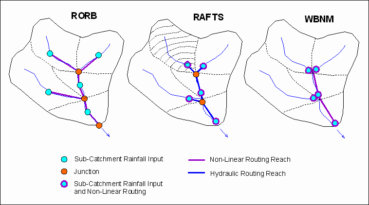
Modelling facilities based on RORB, RAFTS and WBNM have been included in DRAINS. The three models have different structures, as shown below:

RORB has a well-defined structure, with nodes located close to sub-catchment centroids. Routing is only carried out in the stream reaches. There is modelling of losses at nodes but no routing.
By contrast, RAFTS can carry out routing at nodes representing sub-catchments, and also in stream reaches, where flows can be translated or routed using the Muskingum-Cunge method, based on the reach cross-section and roughness. The layout of RAFTS models is flexible, and positions of sub-catchment nodes and lengths of reaches can be set in ways that do not exactly reflect the model structure. The routing within sub-catchments differs from RORB and WBNM in that flows are commonly routed through 10 successive non-linear storages, as indicated in the figure above.
In WBNM, routing occurs at the sub-catchment nodes and in stream reaches that convey runoff from upstream sub-catchments through the local sub-catchment. Like RAFTS, it is flexible, and can be set out in different configurations.
To fit these different structures into the DRAINS framework, it has been necessary to apply different property sheets and relationships between model sub-catchments and stream routing reaches. These are described in the RORB model layout, the RAFTS model layout, and the WBNM model layout.
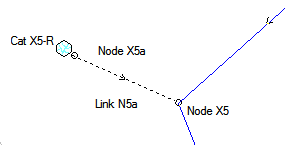
A Horton (ILSAX) hydrological model (and other hydrograph-producing models) can be combined with one of the storage routing model types. Since the Horton (ILSAX) model is usually applied with detailed pipes and channels, it may not be possible to connect nodes and links of the storage routing model directly to parts of the pipe or channel system. DRAINS will provide warnings about this. However, it will be possible to make connections using dummy elements such as nodes, channels and overflow routes, as shown below.

Learn more about:
- RORB Storage Routing Models
- RAFTS Storage Routing Models
- WBNM Storage Routing Models
- Catchments
- Sub-catchments
- Hydrograph