Horton (ILSAX) Sub-catchment property sheet
This is used to enter data for the Horton (ILSAX) hydrological model, the standard model applied in DRAINS before the ARR 2019 IL-CL model was introduced. A slightly different sheet is used for the rational method, and other formats are used for storage routing model sub-catchments.
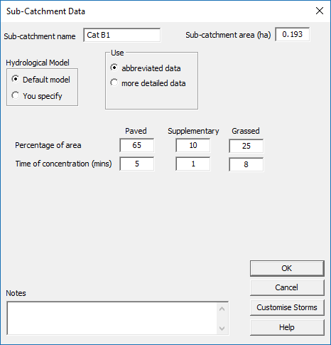
At the top there is a text box for the sub-catchment name, another for entering the sub-catchment area, and option buttons for the 'Hydrological Model' that give the choices 'Default model' and 'You specify'. If you choose the latter, a scrolling list appears below, enabling you to select from available models. You can vary the hydrological model characteristics across the whole catchment, with different soil types or catchment conditions.
Beside the Hydrological Model buttons there is another set of option buttons for selecting the level of data required as: abbreviated data, or more detailed data.
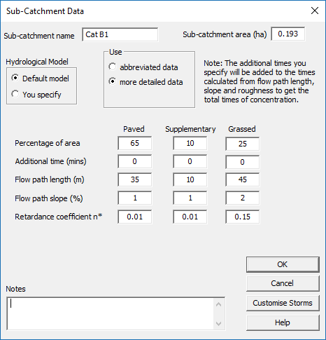
If you select the second option, more text boxes for data entry and display will appear. Text boxes for the paved, supplementary and grassed area surface types are arranged as an array with three columns. In the first row, you can enter the percentages of each surface type within the sub-catchment.
The following rows are for the information needed to determine times of entry or travel times. As options providing more detail are chosen, more text boxes appear for entering the data required to determine times of travel.
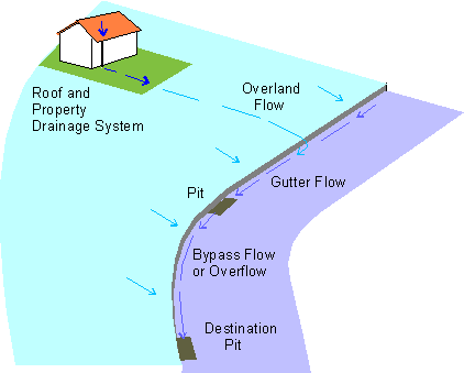
The times determined are additive and relate to different flow paths. For a paved area, the times involved are:
a constant time (which can represent property drainage time plus street gutter flow time)
+ an overland flow time calculated from length, slope and roughness (more detailed data option).By choosing different options or by setting factors such as constant times to zero, many choices are possible. Overland flow times are calculated using the kinematic wave equation described in Australian Rainfall and Runoff, 1987 (pages 300-301). The property drainage time can be taken to be 1 minute for new buildings and 2 minutes for older, deteriorated systems. The gutter flow time can be determined by assuming a suitable velocity, based on trial calculations with the gutter cross-section being used.
a constant time (both options)
+ an overland flow time calculated from length, slope and roughness (more detailed data option).
a constant time, which can represent property drainage time (both options)
+ an overland flow time calculated from length, slope and roughness (more detailed data option).
Some time ago, this sheet has been simplified with the removal of an obsolete third option for entering time calculation data, the comprehensive data option. Because this would have been used in some older DRAINS models, it can still be applied with these. A grassed area lag time can be selected with the abbreviated data or more detailed data options. DRAINS had a 'Customise storms' button at the bottom right of the property sheet to allow complex rainfall patterns, with rainfall intensities varying in time and space, to be applied.
Related Articles
Sub-Catchment property sheet (superseded)
The older form of the property sheet for Horton (ILSAX) sub-catchments is shown below. A similar form of model was used with the rational method and extended rational method procedures, with the land-use types being impervoius and pervious, rather ...IL-CL Sub-Catchment property sheet
This is used to enter data for the ARR 2019 IL-CL model. Different sheets are used for Horton (ILSAX) and the rational method, and other formats are used for storage routing model sub-catchments. At the top there is a text box for the sub-catchment ...Sub-Catchment (Rational Method and ERM) property sheet
This appears when a ratrational method or extended rational method (ERM) model has been specified as the default model in the Hydrological Model dialog box called from the Hydrological Models option in the Project menu. The form of the box will ...Horton (ILSAX) Hydrological Model property sheet
This window enables you to enter, view or edit rainfall-runoff models. The data involved are: the name of the model (e.g. Manly Beach Model), depression storages (mm) for paved, supplementary and grassed areas, a soil type for the grassed or pervious ...Sub-Catchment drawing tool
This tool, , is used to draw sub-catchments in the Main Window. Since it is wrong to place a sub-catchment directly over a pit, the pit will snap to the top, right hand side of the pit. It can then be moved to other sides of the pit, if desired. ...