Exporting TS1 files
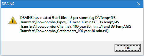
As well as being able to export individual hydrographs from displays of results, DRAINS can also export all hydrographs calculated in a run from every sub-catchment, pipe, overflow route and channel. This is done in the File menu option File ► Export ► Tuflow TS1 Files. When it is chosen a message similar to the following one appears:
The saved files are in a comma-separated format used by the Tuflow program (www.tuflow.com) which is used for 1- and 2-dimensional flood modelling:
The saved files are in a comma-separated format used by the Tuflow program (www.tuflow.com) which is used for 1- and 2-dimensional flood modelling:
This can be read in text editors and spreadsheets, and can be used to transfer DRAINS results to HEC-RAS, Tuflow and other hydraulic programs.
Hydrographs along overflow routes are included in the 'channel' outputs.
Related Articles
Importing and Exporting GIS Files
DRAINS provides transfers of system data and results to between GIS programs and DRAINS, reading from and creating ESRI (ArcView) shapefiles and Mapinfo MIF files, the most commonly-used GIS formats. This facility is not standard in DRAINS, but is ...Exporting MapInfo files
It is first necessary to establish a system that is capable of being run, such as the demo example shown below: Selecting the MapInfo files option from the File -> Export menu presents the following message: If you continue, you will then need to ...Exporting DXF files
You can create a DXF file containing a plan of pipes and pits from the File menu. In the DXF files produced by DRAINS, pipes are represented by lines and nodes are represented by circles. These can be on different layers if you wish. One text value ...Importing MapInfo files
This process enables you to import data into DRAINS from one to six sets of MapInfo files, plus an optional background from a DXF file. The procedure is pretty much the reverse of the exporting process for MapInfo files. MapInfo stores spatial ...Importing ESRI files
This process enables you to import data into DRAINS from one to six sets of ESRI or ArcView files, plus an optional background from a DXF file. The procedure is pretty much the reverse of the exporting process for ESRI files. ArcView stores spatial ...